 |
|
Fly Fishing the
Desolation Wilderness Area
HARD COVER EDITION OF THE BOOK: Second Edition
(Now also available online from Amazon Kindle... Kindle Edition )
I'll try to keep these up to date but do not have a lot of time. There has been little that has changed since these prior editions except that gill netting has removed fish from several lakes. I have not removed these lakes from the guides since I hate to remove a bit of history of the area. That being said, frog populations are expanding exponentially in the Desolation Valley, Highland Lake, Zitella Lake and Clyde Lakes after the netting, which is good news since they now have a sanctuary. Other notable lakes with fish removed include: Lake of the Woods and the surrounding lakes on the west side of the Sierra Crest. The lakes to the east are pretty much untouched and still produce good fishing. Middle Velma is no longer stocked. Cup Lake is still producing good reports and is Clyde Lake and Heather Lake.
This situation is a moving target. If you have particular
interests or some information please send it along and I'll respond
as well as informing Fish and Wildlife about your findings.
by Jerry Yesavage
( yesavage@stanford.edu )
The Desolation Wilderness is a 100 square mile federal "wilderness area" directly to the west of Lake Tahoe, a well-known recreational area on the California/Nevada border with many fishing opportunities. The granite and glaciers of the Sierra Nevada have strongly affected this region leading to the formation of well over 100 lakes of all sizes. There are seven main drainage areas to the Desolation. Below I'll give some brief idea of what to expect starting from Meeks Bay at about the one-o'clock position on a map and then moving around the area clockwise. The USFS has an OK map of the region available in their information centers, though the best is available privately from Tom Harrison.
Permits are available through the National Recreation Reservation Service (NRRS) at Recreation.gov or 1-877-444-6777. Reserved permits can be printed at home or picked up at a Forest Service office within 14 days prior to date of entry. A signed copy of your permit must be in your possession. In addition to Tom's map there is a great new Forest Service Trip Planning Guide.
 |
Meeks Bay/Creek
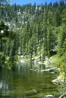
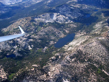
The Tahoe-Yosemite Trail leaves Meeks Bay for Yosemite and is a well-developed major Sierra route. There are fish in Meeks Creek but overgrowth makes it hard to fish until you reach the first lake at 4.6 miles in. At this point there are a series of lakes all of which provide fine fishing. These are often called the Pater Noster Lakes because they are like rosary beads (caused by glacers moving back and forther like bulldozers and leaving terminal morrains as dams). The photo below is looking down the Creek at Stony Ridge Lake and beyond taken by glider pilot James D'Andrea.
 |
This part of the Desolation is known for browns and Crag Lake has some fine fish (see below) that move for minnow imitations. At the top of Phipps Pass is Phipps Lake that is known for excellent brookie fishing. This is primarily an overnight camping area due to the distance to the first lake and requires a wilderness permit. Day permits are available at trailheads but overnight permits must be obtained from a ranger station. The two most convenient are on Highway 50 near Placerville (530-622-5061) and in South Lake Tahoe (530-573-2600). If you are planning to stay overnight, call ahead of time and determine the best way to obtain a permit for your trip.
 |
Eagle Lakes
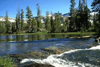
The next main area is the Eagle Lakes Trail that heads in from Emerald Bay. There is also a secondary entrance on the Bayview Trail just south of Emerald Bay. The main attraction here would be the Velma Lakes about 5 miles in. These are stocked with put and grow rainbows which at maturity often reach 15". They are particularly susceptible to damselfly imitations in July and terrestrials, especially grasshoppers, at any time. This is probably the most overused area in the Desolation and is not a place for solitude. Nonetheless there are many secondary lakes that offer a place to get away from it all. For example, Granite Lake up the Bayview Trail a little over a mile has plenty of brookies. Due to the steepness of the trail, it is not often fished (top photo is Granite). A float tube is very useful in this and other lakes of the Desolation. Below is a view of the stream between Upper and Lower Velma Lakes in this drainage.
 |
Fallen Leaf Lake
We next move into the Fallen Leaf Lake area. The main trail in this section goes up the entrance creek to Fallen Leaf at the far end of the lake. Although some fishing can be done in the creek it requires much local knowledge. Very good fishing, however, is available up the trail at Susie (brookies) and Heather (brookies and browns) Lakes. These fish are after minnows and have been taken in over 17" size in both lakes. Brookies fishing slows down after July 1st (depending on snowpack) as the water warms and one is best off searching for a lake with rainbows that still surface feed in the middle of summer.
Echo Lakes
The next drainage is Echo Lakes. One of the best points about this entrance is the water taxi that is available out of Echo Lakes Lodge. The folks there will for a modest fee drop you at the head of the lakes and make arrangements to pick you up later. This saves miles of hiking and makes it ideal for a day trip. Tamarack Lake is the closest lake to the end of the water taxi route and suffers from over use. However, right next to Tamarack are Ralston and Cagwin Lakes that provides less used alternatives with plenty of fish and solitude. The people at the Lodge can give you some information about local conditions depending on what time of year you go.
Desolation Valley
Continuing down Highway 50 the next useful entrance is the trail for Horsetail Falls from Twin Bridges. This very steep trail is only for experienced and confident hikers (see USFS warnings). From its top there are a number of small pretty lakes within easy walking distance (assuming you get an early start). One of the more interesting lakes up here is lake of the Woods that is heavily used but has large fish and extensive weedbeds. This lake can also be reached from the Echo region but from either entrance is a very long day-trip. Most of the small lakes in this area have brookies and provide pleasant recreation. The number of people on the Horsetail Falls entrance fall off rapidly as one gains altitude.
Wright's Lake
The next major entrance is the Wright's Lakes region. There are several major trails leading out of this areas. Suffice it to say that in general the first lake on each trail has the worst fishing, but there is very good fishing to be had as you move up with altitude and away from Wright's Lake itself. One pleasant afternoon can be had, for example, by using the Lyon's Lake trail to reach that lake, known for its large brookies, or to move a little further up to Lake Sylvia. This later lake provides the best base camp to climb to the top of Pyramid Peak and has many, probably too many, small brookies. They readily take small attractor dry flies.
Rockbound Valley
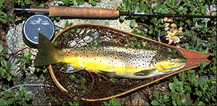
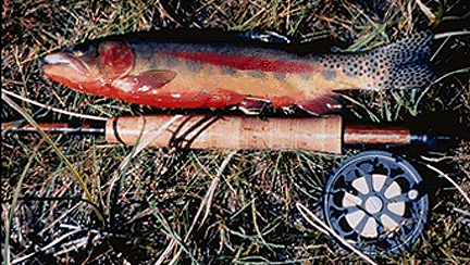
There are several obvious access routes into this isolated area. Luckily for solitude most of the routes involve such distance as to make day trips impossible. This area approximates what the "real" Sierra looks like, i.e. few people and plenty of cross-country route. Just to mention one of the more interesting lakes, Clyde, is at the headwaters of the Rubicon River- this area is accessable via 4-wheel drive roads to the north of the Wilderness. It has been stocked with goldens for many years and they have spread into the river downstream. This provides even the novice angler for a chance to catch a golden in a stream. I should say that catching them bin a lake is much harder. Below is an example of a larger than average Golden from the Desolation.
 |
Further information can be obtained from Jerry Yesavage, CalTrout former Chair of the Board of Governors at yesavage@stanford.edu.
 Return to Jerry Yesavage Home Page