|
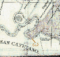
Today I made a comparison of the old map
which I got at the historical society and the
USGS map. Perfect!
Notice the
(a) El 60 contour line indicating a terrace on the
north side of the river; (b) change in
soil type shown by
fruit trees, probably apple; (c) county line;
(d) first break in levee.
The river used to follow the
county line. The change must have been before the
turn of the century because another map at the
historical society, up on the wall, showed the
river in the same place as today. The woman here
said that the date of that map was about 1906.
I wonder, before or after the great earthquake of that year.
|