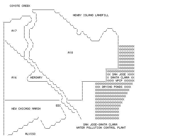
North is at the top. The focus of this map is the area centered on the Alviso Heronry and the Envrionmental Education Center of the San Francisco Bay NWR. On the north is Coyote Creek and the Alameda County line. Coyote Creek branches at the western end of the Newby Island Landfill and the true creek goes north of the landfill and then drops down off the right side of the page, past the CCRS waterbird pond whose official name is the Waterbird Management Area (WMA), past the CCRS trailers, and continues it course back to the Diablo Range. The southern branch of the creek goes part around the south side of the dump and ends in a large mudflat which is visible from CCRS access roads (sometimes). The left border is essentially the main set of railroad tracks that pass by the Alviso Marina.
The right side of the map shows a portion of the sludge drying ponds of the San Jose-Santa Clara Water Pollution Control Plant. At the bottom is Alviso at the left and the New Chicago Marsh which is roughly bounded by Salt Pond A16, Artesian Slough, the EEC entrance road (or maybe we should include the Owens-Corning portion), Spreckles, the town of Alviso, and the railroad tracks. The slough that comes down the map from the upper left is Artesian Slough, sometimes called Mallard Slough, and is, I believe, largely freshwater effluent from the WPCP. Partway up Artesian Slough is the famed Alviso heronry where Great Egret, Snowy Egret, and Black-crowned Night Herons breed every year; Little Blue Herons and Cattle Egrets breed some years; and we all wonder if White-faced Ibis have nested there at least once. I don't know if Great Blue Herons nest there at all.
There is good access to parts of New Chicago Marsh, Artesian Slough, and Salt Pond A16. In recent years the former tidal slough in New Chicago Marsh next to Spreckles has held some good shorebirds which are normally observed either at the corner of Spreckles and Grand or Spreckles and State. If you are a member of CCRS you can drive in past the waterbird pond and, depending upon soil wetness and recent construction, you can drive to the edge of Salt Pond A18 or the end of the Coyote Creek channel that passes south of Newby Island dump.
I don't have an appropriate name for the large, tidal mudflat here - I've sometimes called it the old Coyote Creek delta, but I don't know why. Maps of a hundred years ago, long before Newby Island was anything more than high marsh, show Coyote Creek following its present channel. Why won't the San Jose-Santa Clara WPCP folks let us bird their lovely drying ponds so we can all see Buff-breasted Sandpiper? Good question. Now there's a good project for a Santa Clara County resident. [WGB, 2 Jan 97]