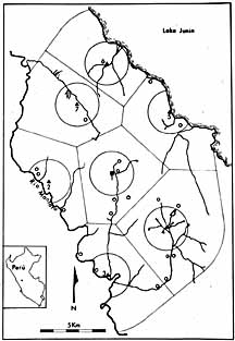
Map of site distribution around Pachamachay, Junin
|
This map shows the area around the base camp of Pachamachay. Square 1
in the middle represents the site of Pachamachay itself. Other sites are
represented either with a small triangle for a secondary site with moderate evidence of occupation or a
small circle for a site that had only scant occupation debris. The large
circles are areas nearest the more important sites; judging by the large amount of riverine area within these, the camps seem to be placed in areas of prime
vicuna
habitat. The
polygons are drawn to divide the territory equally between the neigboring sites. Note that each of the areas thus defined includes either a full river drainage, or a significant segment of one, and the dividing lines themselves fall very close to the watershed boundaries. This pattern
suggests that the creek and river drainages were determining factors for preceramic people
deciding where to establish a camp. The fact that vicuna are the prime resource tied to rivers suggests that this settlement pattern was designed to optimize vicuna hunting possibilities.
|