The Stanford Chavín Project
The final product of the project will integrate all aspects of this research. A three-dimensional computer model based on exterior and interior architectural data will link with the virtual reality panoramas and video documentation for each area of the site. Together they will form a "virtual fieldsite" or "hypothesis tester," with which people can walk through a virtual Chavín, making observations, forming hypotheses about the construction of the site, its astronomical alignments, and yet-unknown aspects of the site, and then test them with the precise measuring capabilities of the site model.The model will be widely available on CD-ROM to archaeologists and the wider public. In the meantime, a CD-ROM of panoramic images of Chavin (including quite a number not included on this web site) and other Andean sites is available. Contact John Rick by email at johnrick@stanford.edu
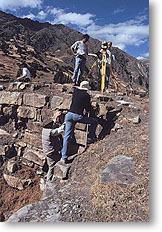
Teams of Stanford students led by John Rick have conducted fieldwork at Chavín in the summers of 1995 and 1996. The primary goal of the project is to accurately map the site using theodolite surveying technology; in these two seasons, the teams collected over 25,000 measured points, documenting the site topography, exterior architecture, and exterior sculptures. A number of sub-projects augment the greater mapping project. These include mapping the internal labyrinthine passageways known as the galleries, video-taping detailed interviews with the elderly and extremely knowledgeable site caretaker, and creating the virtual reality panoramas seen on this web-site. Individual students have conducted their own research at the site, resulting in undergraduate honors theses on significant topics such as site construction labor and the feline-human sculptures known as tenon heads. Fieldwork at Chavín will continue in the summer of 1998.